Full description not available

D**Z
Just as described.
Great
C**
Just what I wanted
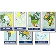
I've been looking for some maps that depict the basics only, instead of trying to include a mountain of information in a very small space. The continents are clearly outlined, as well as the borders for each country. Each country is also in a different color making size comparisons easier as and making it easier to find a particular country. Except for the really large countries the only cities marked are the capitol cities. Mountain ranges aren't included. Bodies of water aren't refined to show depth by changes of shade. There's just one shade of blue to show all water. The material of the map feels like vinyl, as opposed to laminated paper. These are great basic maps to help a person easily see the layout of countries and bodies of water within or near each country. These would be excellent tools for school teachers and are a basic for home libraries.
A**E
Hard to flatten, but pretty nice
Map of the Continents 7 Poster Set are a nice starter set of maps for kids. With so many electronics, it's nice to have a bigger map to use to show your kids or grandkids the different continents and countries. The maps have a glossy finish, but are not really laminated. They arrive in a paper tube, but because they are rolled up, it is very hard (even reverse rolling them) to get them to lie flat. That is still a work in progress. The printing is not super crisp, but is still readable. I do wish that there were a bit more detail (US states' names, for example), but it's still fun looking at the different countries with the kids.
R**E
helpful teaching tool
I like the size and sturdiness of the maps. They aren't too hard to flatten if you've had experience doing it and a little patience. I think this is a really nice set, and I like the perspective of the continents relative to the poles. What I don't like is that North America is missing some things. It's ok if some of the islands are missing - it doesn't have to be that comprehensive, but it's missing Costa Rica and Panama! They show up on the South America map. Because of this inaccuracy, I've taken off one star. I hope they'll correct it. I'd also love to see lighter or smaller lines showing boundary lines for states/provinces, even if they're not specifically labeled. It would be helpful for lessons.
T**Y
Like the look and feel of the maps
I got these for a strange reason. We have traveled all over the world, and I decided after seeing these maps online I would like to put a “pin” for every State and Country we have been to. The come as individual maps all rolled up. It took some time to “flatten” them all. I really like the look and feel of the maps. Looking at them all together is pretty cool. Now we need to decide where our next trip will be.
N**R
Beautiful set of maps
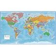
We got these to add to our home schooling equipment. They’re really good quality nice and thick paper. They come in a convenient tube to be stored. Printed clearly.
I**U
Glorious maps with vintage feel
These are so lovely. I haven't seen nice poster-size maps in years, and these are wonderful. Are they perfect? No, they do have slightly fuzzy print, and they are very slightly out of date (Swaziland rather than Eswatini) but all of that adds to the rich beauty of this snapshot of the world. The colors are good and saturated. The paper is rolled but it does flatten after some time rolled the other way. For the current $10 price, they're a steal. They aren't perfect, but in a way, they are.
A**R
I would not recommend these.
Way over priced. I was excited to get the set, but the print quality is fuzzy. Also, they sent it in a poster tube and are hard to then flatten out to actually use in your classroom. I would not recommend these.
Trustpilot
1 month ago
2 weeks ago